Report Overview
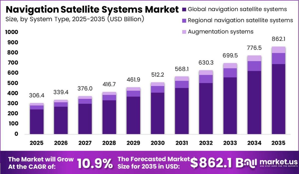
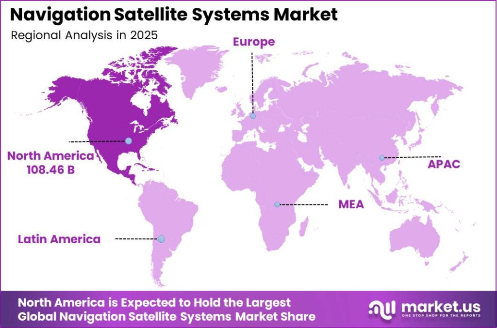
In 2025, the Global Navigation Satellite Systems Market was valued at US$306.4 billion, and between 2026 and 2035, this market is estimated to register a CAGR of 10.9%, reaching about US$862.1 billion by 2035. North America held a dominant market position, capturing more than a 35.40% share, holding USD 108.46 billion in revenue.
The global navigation satellite system (GNSS) market is growing due to the strict government regulations for multi-frequency public safety systems and rapid growth of commercial autonomous transportation systems. However, expansion is severely limited by massive initial satellite manufacturing CapEx and signal attenuation in dense urban canopies.
- According to market reports by the European Union Agency for the Space Programme (EUSPA), the global installed base of Global Navigation Satellite System (GNSS) devices has surpassed 10.6 billion units, driven by the rise of multi-constellation smartphones and connected cars.
The scope of the market includes full-fledged technology segments such as worldwide networks (GNSS), regional architectures (RNSS) and satellite based augmentation networks (SBAS). High-precision capacity scales from standard multi-meter positioning to specialized sub-decimeter and centimeter level RTK data processing engines. The long-term future outlook aligns with pervasive artificial intelligence (AI) optimization, utilizing machine learning algorithms directly at the chip level to counter atmospheric signal delays and enhance positional integrity across automated networks.
Key Takeaways
- The Global Navigation Satellite Systems Market was valued at US$306.4 billion in 2025.
- The Global Navigation Satellite Systems Market is projected to grow at a CAGR of 10.9% and is estimated to reach US$862.1 billion by 2035.
- By component, devices led the market, capturing 57.10% of the total market share.
- Based on system type, global navigation satellite systems (GNSS) dominated the market, with a substantial share of 80.10%.
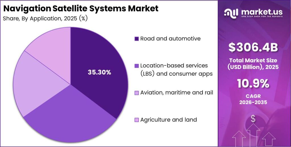
- Among the applications, the road and automotive sector held the major share, accounting for 35.30% of the market.
- In terms of geography, North America was the most dominant region within the market, constituting 35.40% of the total global demand.
Component Analysis
Devices Represents Dominant Segment in the Market
The devices segment dominated the Navigation Satellite Systems market with a share of 57.10% during the 2024–2025 base year, driven by rising investments in multi-frequency GNSS chips, in-vehicle telematics systems, and high-accuracy ground control receivers. The high cost of hardware procurement and recurring replacement cycles contributes to significant capital expenditure (CapEx), supporting strong long-term return on investment (ROI).
The services segment’s rapid growth is fueled by heavy urban development, real-time micro-mobility apps, and high data usage by businesses, pushing the industry toward high-profit, cloud-based subscription software. Augmentation and RTK Correction services are becoming the main trend for the 2030–2035 period. These services are driven by the rise of autonomous drones and smart grid systems.
System Type Analysis
Global Interoperability Establishes GNSS Supremacy
Global Navigation Satellite Systems (GNSS) dominated the market, accounting for 80.10% of the total volume during the 2024–2025 base period, driven by extensive satellite networks operating across multiple semiconductor technology layers to provide continuous and widespread positioning information. The segment’s strong market position is further supported by long-standing international agreements, standardized global technical frameworks, and deep integration with consumer electronics across diverse industries.
Regional Navigation Satellite Systems (RNSS) are leading the way in growth as countries align politically and the rise of new economies focusing on building their own technology to ensure national security. At the same time, Satellite-Based Augmentation Systems (SBAS) are becoming the main trend for the years 2030 to 2035. These systems focus on passive tracking and real-time checks of signals to ensure high reliability. They are being pushed forward by industries like self-driving cars and automated shipping, but there are still major challenges in getting aerospace certifications, which are holding back progress in the short term.
Application Analysis
Road and Automotive Are the Most Widely Used Application Verticals
The Road and Automotive segment dominated the market, accounting for a 35.30% share during the 2024–2025 base year, driven by the increasing deployment of multi-layer connected dashboard hardware and large-scale commercial logistics fleet systems. The segment’s strong market presence is further supported by evolving automotive safety regulations and rising consumer demand for smart dashboard navigation solutions.
The Location Based Services (LBS) market is currently the fastest growing segment. The growth is supported by urbanization trends, expansion of gig economy delivery systems, and low-power miniaturized chipsets which help save the battery of wearables. The Industrial Automation market represents the major future trend (2030–2035). Centimeter-accurate automated equipment fueled by AI optimization in agriculture and industrial processes is deployed in this segment. The limitations include high capital expenses associated with converting vehicle fleets, as well as absence of standards in communications.
Key Market Segments
By Component
- Devices
- GNSS chipsets and receivers
- In‑vehicle navigation units and handheld devices
- Satellites and ground control infrastructure
- Services
- Positioning, navigation and timing services
- Fleet tracking and location‑based service platforms
- Augmentation and correction services
By System Type
- Global navigation satellite systems (GNSS)
- Regional navigation satellite systems (RNSS)
- Augmentation systems (SBAS and others)
By Application
- Road and automotive
- Location‑based services (LBS) and consumer apps
- Aviation, maritime and rail
- Agriculture and land
Market Drivers
| Driver | (~) % Impact on CAGR Forecast | Geographic Relevance | Impact Timeline |
|---|---|---|---|
| Autonomous mobility and robotics deployment | +2.5% | North America, Europe, East Asia | Short term (≤ 2 years) |
| Precision agriculture adoption | +1.9% | North America, Latin America, Europe, Australia | Medium term (2–4 years) |
| Location-based logistics services | +1.5% | Global | Short term (≤ 2 years) |
| High-accuracy multi-constellation availability | +1.2% | Europe, North America, Asia-Pacific | Short term (≤ 2 years) |
| Critical timing infrastructure demand | +0.8% | North America, Europe, East Asia | Medium term (2–4 years) |
Autonomous mobility and robotics deployment
Autonomous vehicles, unmanned aircraft, robotics and advanced logistics systems require continuous, high-integrity positioning, navigation and timing inputs to plan routes, maintain geofences, coordinate fleets and support safety functions. This moves the navigation-satellite market beyond commodity consumer receivers toward multi-frequency modules, inertial integration, correction services, anti-spoofing software and fleet-management platforms.
The Galileo High Accuracy Service provides global corrections enabling positioning errors below 20 centimetres in nominal conditions, while the service has been available since 2023 without user fees. High-accuracy services reduce dependence on local correction networks and allow autonomous operators to improve route efficiency and asset utilization; an integrated GNSS-inertial solution can reduce position error materially relative to single-frequency standalone navigation. This shift to safety-critical, subscription-enabled navigation contributes an estimated +2.5% to the 10.9% baseline CAGR.
Market Restraints
| Restraint | (~) % Impact on CAGR Forecast | Geographic Relevance | Impact Timeline |
|---|---|---|---|
| High sovereign constellation investment | -1.8% | Global upstream infrastructure | Short term (≤ 2 years) |
| Export-controlled receiver components | -1.2% | North America, Europe, East Asia | Short term (≤ 2 years) |
| Spectrum allocation restrictions | -0.8% | Global | Medium term (2–4 years) |
| Public procurement cycle delays | -0.6% | Europe, North America, emerging markets | Short term (≤ 2 years) |
| Ground-based positioning substitution | -0.4% | Urban North America, Europe, East Asia | Medium term (2–4 years) |
High sovereign constellation investment
Building and renewing navigation-satellite constellations requires long-duration sovereign investment in satellites, launches, ground control, monitoring stations, signal security and end-of-life replacement, creating a material funding barrier for upstream market participation. The cost is amplified by the need to maintain uninterrupted global service while next-generation systems are developed and deployed.
Satellite modernization delays can postpone downstream receiver design cycles and defer high-accuracy service commercialization, while national budget reprioritization can reduce procurement certainty for prime contractors and subsystem suppliers. The financial exposure is compounded by long development windows that can extend beyond 10 years, tying up engineering capacity and capital before full service revenue is realized. Suppliers commonly need to carry elevated inventory, testing and qualification costs, raising program risk and reducing returns on capital. This structural capital intensity deducts an estimated -1.8% from the baseline CAGR even as demand for downstream positioning services continues to rise.
Market Challenges
| Challenge | (~) % CAGR Friction Drag | Geographic Relevance | Mitigation Horizon |
|---|---|---|---|
| Jamming and spoofing resilience | -1.6% | Global, especially defense and transport | Long term (≥ 4 years) |
| Urban multipath accuracy degradation | -1.1% | Dense cities worldwide | Medium term (2–4 years) |
| Multi-constellation interoperability complexity | -0.8% | Global | Long term (≥ 4 years) |
| Receiver cybersecurity hardening | -0.6% | North America, Europe, East Asia | Long term (≥ 4 years) |
| Precision navigation engineering scarcity | -0.4% | North America, Europe, East Asia | Long term (≥ 4 years) |
Jamming and spoofing resilience
Satellite-navigation signals are weak at the Earth’s surface and can be disrupted by unintentional interference, deliberate jamming, spoofed signals or localized electromagnetic conditions, creating a persistent safety and continuity risk for aviation, maritime operations, emergency response, finance, telecommunications and autonomous systems. Reliance on GNSS alone is therefore insufficient for many critical applications; operators must integrate inertial sensors, multi-frequency receivers, signal-authentication methods, terrestrial augmentation and interference detection.
A resilient navigation architecture can add an estimated 15–35% to receiver and integration cost relative to a basic single-band device, while validation and field testing can extend product cycles by roughly 9–18 months. The Global Positioning System is a United States-owned utility providing positioning, navigation and timing services, underscoring the critical-infrastructure nature of the dependency. Continuous investment in resilient PNT architectures is required, creating an estimated -1.6% drag on maximum market growth without eliminating current demand.
Market Opportunities
| Opportunity | (~) % Potential CAGR Upside | Geographic Relevance | Execution Window |
|---|---|---|---|
| Resilient PNT assurance subscriptions | +2.2% | North America, Europe, East Asia | Medium term (2–4 years) |
| Integrated satellite-terrestrial positioning | +1.7% | Global urban markets | Long term (≥ 4 years) |
| Carbon-monitoring geospatial platforms | +1.3% | Europe, North America, Asia-Pacific | Medium term (2–4 years) |
| Precision agriculture service bundles | +1.0% | North America, Latin America, Europe, Australia | Medium term (2–4 years) |
| Low-power mass-market receiver modules | +0.7% | South Asia, Southeast Asia, Africa | Long term (≥ 4 years) |
Resilient PNT assurance subscriptions
Resilient positioning, navigation and timing assurance is future white space because most navigation revenue remains concentrated in hardware receivers and free signal access rather than recurring verification, integrity monitoring and contingency-navigation services. A subscription offering can combine real-time interference alerts, spoofing detection, signal-quality analytics, multi-constellation integrity scoring and fallback guidance for fleet, infrastructure and industrial customers.
The opportunity expands as constellation resilience improves: 2 additional Galileo satellites entered service on 29 January 2025, and further first-generation satellites were scheduled for deployment in 2025 and 2026 to increase robustness. A managed assurance layer can reduce navigation-related incident investigation time by an estimated 20–40% and increase customer retention through continuous monitoring, shifting economics from one-time module sales toward recurring software revenue. At scale, this model could expand gross margins by roughly 300–600 basis points and add an estimated +2.2% above the 10.9% baseline CAGR.
Geopolitical Impact Analysis
A Battlefield Shift: Active Electronic Warfare and Geopolitical Tension Reshape Global Satellite Tracking
The ongoing conflicts in Eastern Europe and the Middle East region have turned space-based technology from mere commercial services into tools of power. The idea of a universal access GNSS has been obliterated by electronic warfare capabilities, where jamming and spoofing techniques have evolved into large-scale market disruptions. Jamming in the Eastern Europe region has caused more than 50,000 commercial flights to be grounded, forcing civil aviation and logistics companies to rely on either alternative navigation means or old-school inertial navigation.
As a result, the “GPS-denied” navigation market is forcing hardware providers to design multi-layered solutions. Both military and commercial organizations are seeking to diversify their infrastructure investments to avoid a signal being turned off on a large scale. Emerging markets are moving money into creating RNSS for themselves, like India’s NavIC constellation, to ensure the safety of critical tracking infrastructure.
Regional Analysis
North America Held the Largest Share of the Navigation Satellite Systems Market
North America dominated the market ecosystem, accounting for a 35.40% share during the 2024–2025 base year period, driven by strong technological infrastructure, widespread adoption of satellite navigation systems, and increasing demand across automotive, defense, and logistics applications. The region’s leadership is further strengthened by the presence of advanced aerospace and defense industries, early adoption of next-generation navigation technologies, and stringent regulatory requirements for high-precision multi-frequency tracking across aviation and military infrastructure.
In addition, rising investments in autonomous vehicle technologies, connected transportation systems, and smart mobility platforms continue to accelerate GNSS deployment across the region. The strong presence of leading satellite technology providers and ongoing modernization of positioning, navigation, and timing (PNT) infrastructure also contribute to North America’s sustained market dominance.
Asia-Pacific has the greatest forward momentum in terms of growth. Fueled by rapid urbanization and huge consumer technology centers, as illustrated by World Population Review statistics, Asia-Pacific demonstrates a significant amount of human resources scaling high volumes of mobile tracking and connected wearables as well as local gig-economy delivery services.
On the other hand, Europe and emerging sovereign regional clusters are expected to represent key growth regions during the 2030–2035 period, driven by evolving geopolitical dynamics and an increasing emphasis on technological sovereignty. Governments across these regions are actively investing in localized satellite navigation infrastructure to ensure secure, resilient, and uninterrupted positioning services within their national and regional boundaries, strengthening independent positioning, navigation, and timing (PNT) capabilities.
Key Regions and Countries Covered in this Report:
North America
- The US
- Canada
Europe
- Germany
- France
- The UK
- Spain
- Italy
- Russia & CIS
- Rest of Europe
APAC
- China
- Japan
- South Korea
- India
- ASEAN
- Rest of APAC
Latin America
- Brazil
- Mexico
- Rest of Latin America
Middle East & Africa
- GCC
- South Africa
- Rest of MEA
The GNSS market follows a two-tier structure with a sovereign oligopoly at the upstream level, and a high consolidation at the downstream level. The space segment is characterized as a strict sovereign oligopoly where state-owned organizations control the four major GNSS constellations; GPS operated by the US, Galileo by the EU, BeiDou by China, and GLONASS by Russia. The enormous costs involved in deploying and maintaining satellite constellations act as absolute barriers to entry, excluding any private commercial entities from owning the basic transmission frequencies for their operations.
On the other hand, the downstream segment, which includes hardware chipsets, multi-frequency receivers, and specialized software solutions, remains highly consolidated, with a limited number of multinational players holding a dominant share. Leading technology companies such as Qualcomm, Broadcom, and MediaTek maintain significant influence across consumer electronics and automotive telematics applications, particularly within GNSS-enabled components.
Additionally, the precision vertical segments such as industrial, surveying, and military applications are highly concentrated within engineering primes such as Trimble, Hexagon AB, and u-blox. Leading players in the market invest heavily in research and development to develop multi-frequency RF front-ends, thereby erecting technological moats that shield hardware startups from entering the market.
The following are some of the major players in the industry:
- Lockheed Martin Corporation
- RTX Corporation (Raytheon)
- Northrop Grumman Corporation
- Airbus Defence and Space
- Boeing Company
- China Aerospace Science and Technology Corporation (CASC)
- Indian Space Research Organisation (ISRO)
- European Space Agency (ESA) / EUSPA
- Qualcomm Technologies Inc.
- Broadcom Inc.
- MediaTek Inc.
- Intel Corporation
- STMicroelectronics N.V.
- Hexagon AB
- Garmin Ltd.
- Trimble Inc.
- TomTom N.V.
- u‑blox Holding AG
- Topcon Corporation
- Others
Key Developments
- In March 2026, Qualcomm and MediaTek advanced their Direct-to-Cell offerings through next-generation chipset and modem upgrades, including Qualcomm’s Snapdragon Wear Elite platform with the R19-Ready X105 modem and MediaTek’s validated satellite messaging solution with Starlink Mobile, marking progress toward unified D2D connectivity in consumer devices.
- In April 2026, Trimble expanded its industrial software portfolio through the acquisition of Document Crunch, an AI-driven compliance and contract review platform, integrating advanced risk mitigation capabilities into its project delivery ecosystem and accelerating its shift toward higher-margin subscription-based software services.
Report Scope
| Report Features | Description |
|---|---|
| Market Value (2025) | US$306.4 Bn |
| Forecast Revenue (2035) | US$862.1 Bn |
| CAGR (2026-2035) | 10.9% |
| Base Year for Estimation | 2025 |
| Historic Period | 2020-2024 |
| Forecast Period | 2026-2035 |
| Report Coverage | Revenue Forecast, Market Dynamics, Competitive Landscape, Recent Developments |
| Segments Covered | By Component (Devices, Services), By System Type (Global navigation satellite systems (GNSS), Regional navigation satellite systems (RNSS), Augmentation systems (SBAS and others)), By Application (Road and automotive, Location‑based services (LBS) and consumer apps, Aviation/maritime and rail, Agriculture and land) |
| Regional Analysis | North America – The US & Canada; Europe – Germany, France, The UK, Spain, Italy, Russia & CIS, Rest of Europe; APAC – China, Japan, South Korea, India, ASEAN & Rest of APAC; Latin America – Brazil, Mexico & Rest of Latin America; Middle East & Africa – GCC, South Africa, & Rest of MEA |
| Competitive Landscape | Lockheed Martin Corporation, RTX Corporation (Raytheon), Northrop Grumman Corporation, Airbus Defence and Space, Boeing Company, China Aerospace Science and Technology Corporation (CASC), Indian Space Research Organisation (ISRO), European Space Agency (ESA), Qualcomm Technologies Inc., Broadcom Inc., MediaTek Inc., Intel Corporation, STMicroelectronics N.V., Hexagon AB, Garmin Ltd., Trimble Inc., TomTom N.V., u‑blox Holding AG, Topcon Corporation, Others. |
| Customization Scope | Customization for segments, region/country-level will be provided. Moreover, additional customization can be done based on the requirements. |
| Purchase Options | We have three licenses to opt for: Single User License, Multi-User License (Up to 5 Users), Corporate Use License (Unlimited Users and Printable PDF) |