Report Overview
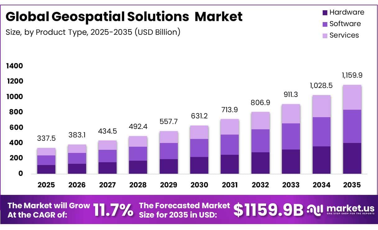
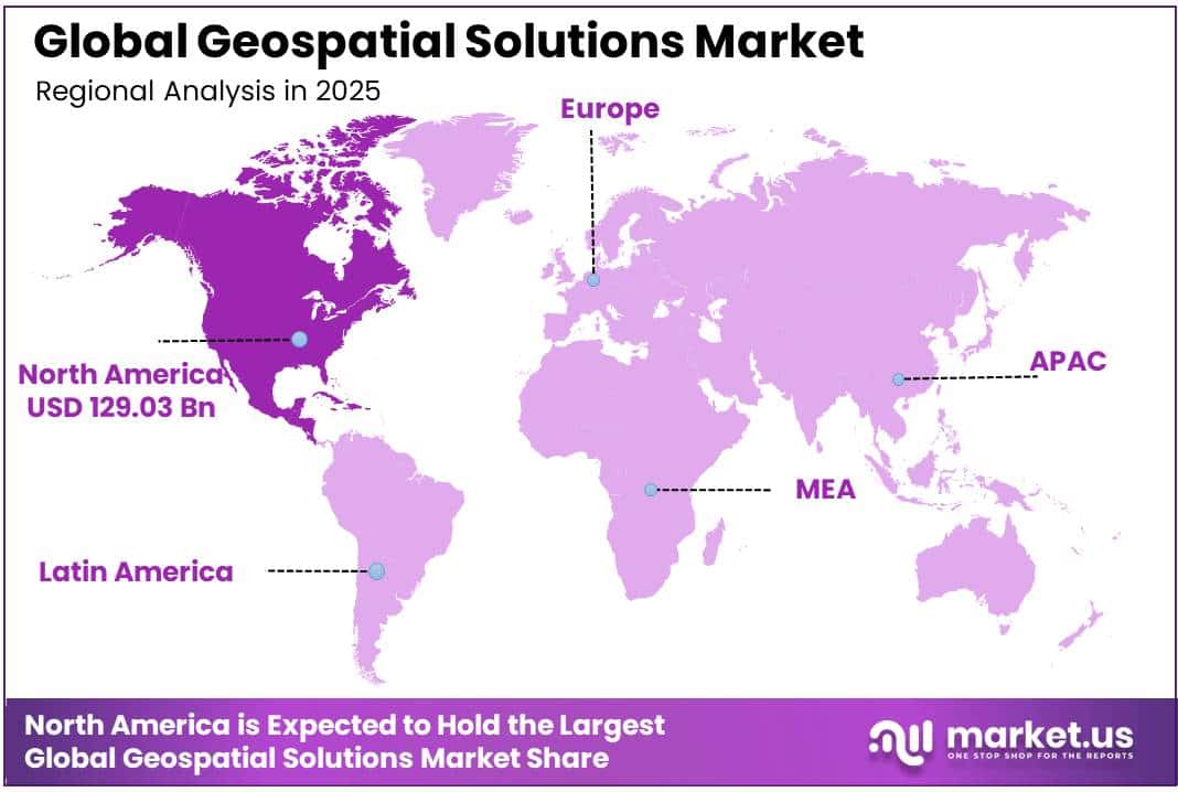
In 2025, the Global Geospatial Solutions Market was valued at US$337.5 billion, and between 2026 and 2035, this market is estimated to register a CAGR of 11.7%, reaching about US$1,159.9 billion by 2035. North America held a dominant market position, capturing more than a 38.2% share, holding USD 129.03 billion in revenue.
Key Takeaways
• The global Geospatial Solutions Market was valued at US$337.5 billion in 2025.
• The global Geospatial Solutions Market is projected to grow at a CAGR of 11.7% and is estimated to reach US$1,159.9 billion by 2035.
• On the basis of solution type, the software segment dominated the market, constituting 37.3% of the total market share.
• Based on the application, geospatial data management dominated the market, with a substantial market share of around 64.34%.
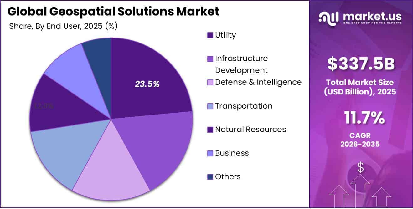
• Among the end users, the utility segment held a major share in the geospatial solutions market, accounting for 23.5% of the market share.
• In 2025, North America was the most dominant region in the geospatial solutions market, accounting for 38.2% of the total global market share.
The Global Geospatial Solutions Market is experiencing steady expansion as organizations increasingly leverage location-based intelligence to enhance decision-making, operational efficiency, and resource management. Geospatial technologies, including Geographic Information Systems (GIS), remote sensing, Global Navigation Satellite Systems (GNSS), and spatial analytics, have become essential tools across industries such as agriculture, transportation, utilities, environmental monitoring, urban planning, and defense. The growing adoption of digital transformation initiatives and data-driven planning strategies is strengthening the role of geospatial solutions in both public and private sectors.
The current industry scenario is characterized by increasing availability of Earth observation data and advancements in satellite technology.
- According to the Satellite Industry Association, the total number of operational satellites in orbit worldwide reached 11,539 by the end of 2024, significantly expanding the availability of geospatial data and strengthening satellite-based capabilities for commercial, scientific, environmental, and government applications.
Furthermore, the European Union’s Copernicus Programme provides free and open access to data from the Sentinel satellite constellation, generating petabytes of Earth observation information annually to support environmental monitoring, climate assessment, disaster management, and land-use planning.
Key market drivers include rising demand for real-time spatial analytics, increasing investments in smart city development, expanding use of location-based services, and growing requirements for infrastructure monitoring and environmental sustainability. Government initiatives promoting digital mapping, climate resilience, and disaster preparedness are further supporting industry growth. Future opportunities are expected to emerge from artificial intelligence-enabled geospatial analytics, digital twins, autonomous navigation systems, precision agriculture, and advanced satellite imaging technologies. The continued expansion of Earth observation infrastructure and integration of geospatial intelligence into enterprise operations are expected to create substantial long-term growth prospects for the global geospatial solutions ecosystem.
Geospatial Solutions Market Segmentation
Solution Type Analysis
Software represents dominant Segment in the Geospatial Solutions Market.
In 2025, Software held a dominant market position, capturing more than a 37.3% share of the global geospatial solutions market. The segment’s leadership was supported by the growing use of geographic information systems (GIS), location intelligence platforms, mapping applications, and geospatial analytics tools across multiple industries. Organizations increasingly relied on software solutions to process, analyze, and visualize large volumes of spatial data, helping improve planning, monitoring, and operational decision-making. The rising adoption of cloud-based geospatial platforms and integration of artificial intelligence into spatial analysis further strengthened demand for software solutions. As businesses and public agencies continued to focus on data-driven operations throughout 2025, software remained the preferred component within the geospatial solutions ecosystem.
The hardware segment represented as the fastest growing segment In the market in 2025. Growth in this segment was supported by the increasing deployment of surveying equipment, drones, satellite receivers, LiDAR systems, and other geospatial data collection devices. Expanding infrastructure projects, environmental monitoring activities, and mapping applications continued to create demand for advanced hardware technologies capable of capturing accurate spatial information across diverse operational environments.
Application Analysis
Geospatial Data Management a significant type.
In 2025, Geospatial Data Management held a dominant market position, capturing more than a 64.34% share of the global geospatial solutions market. This segment remained the most widely used as organizations increasingly focused on storing, organizing, and managing large volumes of spatial data generated from satellites, sensors, and mapping systems. The rising need for accurate and reliable geospatial datasets in utilities, infrastructure planning, and government applications supported its strong market position. Continuous expansion of digital mapping activities and growing dependence on location-based data further reinforced its dominance during 2025.
Geospatial Analysis and Visualization represented as the growing segment in the market in 2025. this segment continued to grow steadily as industries increasingly used spatial analytics and visualization tools to interpret geographic data and convert it into meaningful insights. The demand for better decision-making, improved planning accuracy, and enhanced visual representation of spatial patterns supported its rising adoption across multiple end-use sectors.
End User Analysis
Utility dominates the Geospatical Solutions Market
In 2025, Utility held a dominant market position, capturing more than a 23.5% share of the global geospatial solutions market. This segment continued to lead as utility providers increasingly used geospatial solutions for managing complex infrastructure systems such as electricity grids, water distribution networks, and gas pipelines. The growing requirement for real-time asset monitoring and improved service reliability supported the strong adoption of geospatial tools in this sector. Utilities also relied on spatial data to reduce operational downtime, improve maintenance scheduling, and enhance overall network efficiency. Increasing digital transformation initiatives within utility operations further strengthened the use of geospatial technologies throughout 2025, especially in urban service networks and expanding infrastructure zones.
Infrastructure Development represented as the fastest growing segment in the market in 2025. This segment showed consistent growth as geospatial solutions were widely used for construction planning, land surveying, and infrastructure monitoring. The rising focus on smart city development, transportation expansion, and large-scale public infrastructure projects supported demand for accurate spatial mapping and planning tools. Geospatial technologies played an important role in improving project execution, reducing planning errors, and enabling better coordination across development activities.
Key Market Segments
By Solution Type
- Hardware
- Software
- Services
By Application
- Geospatial Data Management
- Geospatial Analysis and Visualization
- Location Intelligence
- Geospatial Infrastructure
- Satellite Remote Sensing
By End User
- Utility
- Infrastructure Development
- Defense & Intelligence
- Transportation
- Natural Resources
- Business
- Others
Drivers
Restraints
Opportunity
Challenges
Geopolitical Impact Analysis
Rising Geopolitical Tensions Driving Demand for Sovereign Geospatial Intelligence Systems
Geopolitical factors are playing a strong role in shaping the geospatial solutions market as countries increasingly view satellite data and mapping intelligence as strategic national assets. Rising global tensions and security concerns are pushing governments to invest in independent Earth observation systems for defense, border monitoring, and intelligence gathering. This shift is increasing demand for secure and sovereign geospatial infrastructure rather than relying on shared international data platforms.
In recent years, several nations have expanded satellite constellations to improve surveillance and real-time monitoring capabilities. According to the European Space Agency (ESA), Earth observation systems generate petabytes of data annually (March 2024), and access to such data is becoming more regulated due to security and privacy concerns. This has led to tighter controls on high-resolution imagery and cross-border data exchange, especially in conflict-sensitive regions.
Geopolitical competition is also affecting supply chains for satellites, sensors, and geospatial software. Export restrictions on advanced semiconductor chips and space-grade components are slowing international collaboration, while encouraging domestic production and localized geospatial ecosystems. At the same time, initiatives like the European Union’s Copernicus program reflect efforts to strengthen regional autonomy in Earth observation and reduce dependence on external providers.
Overall, geopolitics is transforming geospatial solutions into a critical strategic infrastructure supporting defense, security planning, and national resilience.
Regional Analysis
North America Held the Largest Share of the Global Geospatial Solutions Market.
North America held a dominant position in the Geospatial Solutions Market, accounting for 38.2% share with a market value of US$129.03 billion in 2025. The region’s leadership is strongly supported by advanced digital infrastructure, high adoption of location-based services, and extensive use of geospatial intelligence across defense, transportation, utilities, and urban planning sectors. In March 2025, increased federal investment in Earth observation systems and satellite-based monitoring further strengthened demand for high-precision spatial analytics across both government and commercial applications.
The presence of advanced satellite networks and strong integration of AI and cloud computing into geospatial platforms has significantly enhanced real-time data processing capabilities in the region. The United States National Oceanic and Atmospheric Administration (NOAA) continues to expand its Earth observation programs, supporting climate monitoring and disaster response applications that rely heavily on geospatial technologies. Additionally, rising investment in smart city development and infrastructure modernization is increasing the use of geospatial mapping tools for planning and operational efficiency.
Strong participation from technology leaders and defense agencies is further accelerating innovation in spatial intelligence systems. Growing demand for autonomous navigation, predictive analytics, and digital twin technologies is expected to sustain North America’s leadership position, reinforcing its role as the most advanced and mature regional market for geospatial solutions.
Key Regions and Countries Covered
- North America
- The US
- Canada
- Europe
- Germany
- France
- The UK
- Spain
- Italy
- Russia & CIS
- Rest of Europe
- APAC
- China
- Japan
- South Korea
- India
- ASEAN
- Rest of APAC
- Latin America
- Brazil
- Mexico
- Rest of Latin America
- Middle East & Africa
- GCC
- South Africa
- Rest of MEA
Key Players Analysis
The Geospatial Solutions Market shows a moderately consolidated structure, where large technology companies hold a significant share due to their strong cloud infrastructure, AI capabilities, and global mapping ecosystems. Companies such as Google LLC, Microsoft Corporation, Oracle Corporation and Amazon Web Services (AWS) dominate core platform services, particularly in location intelligence, mapping APIs, and cloud-based spatial analytics. Their leadership is supported by continuous integration of AI, real-time data processing, and large-scale user ecosystems, which strengthen their influence across commercial and enterprise applications.
Specialized players such as TomTom International BV, Bentley Systems Inc., and L3Harris Geospatial Solutions Inc. contribute significantly in navigation systems, infrastructure modeling, and defense-grade geospatial intelligence. Emerging firms like Pix4D, GIS Cloud Ltd., and Mappedin Inc. are expanding their presence in drone mapping, 3D visualization, and indoor spatial solutions. Competition is intensifying as companies focus on partnerships, satellite data integration, and AI-driven geospatial analytics to enhance accuracy, speed, and real-time decision-making capabilities across industries.
Market Key Players
- Pix4D
- Microsoft Corporation
- Uber Technologies Inc.
- L3Harris Geospatial Solutions Inc.
- TomTom International BV
- Living Map
- Google LLC
- Mappedin Inc.
- Bentley Systems Inc.
- SAP SE
- Apple Inc.
- GIS Cloud Ltd.
- General Electric Company
- Oracle Corporation
- Telenav Inc.
Key Development
- In June 2025, Pix4D enhanced its drone mapping and photogrammetry solutions, strengthening its capabilities in high-precision 3D spatial data processing for infrastructure planning and environmental monitoring applications.
- In March 2025, Microsoft Corporation advanced its cloud-based geospatial and AI integration within Azure platforms, improving real-time location intelligence and large-scale spatial analytics for enterprise and government users.
- In August 2025, Google LLC upgraded its mapping and geospatial AI systems, improving navigation accuracy, urban modeling, and real-time location-based services across global digital ecosystems.
- In April 2025, Bentley Systems Inc. expanded its infrastructure digital twin and geospatial engineering solutions, enhancing asset performance modeling, construction planning, and infrastructure lifecycle management across transportation and utility projects.
Report Scope
| Report Features | Description |
|---|---|
| Market Value (2025) | US$337.5 Bn |
| Forecast Revenue (2035) | US$1,159.9 Bn |
| CAGR (2026-2035) | 11.7% |
| Base Year for Estimation | 2025 |
| Historic Period | 2020-2024 |
| Forecast Period | 2026-2035 |
| Report Coverage | Revenue Forecast, Market Dynamics, Competitive Landscape, Recent Developments |
| Segments Covered | By Solution Type (Hardware, Software, and Services), By Application (Geospatial Data Management, Geospatial Analysis and Visualization, Location Intelligence, Geospatial Infrastructure, and Satellite Remote Sensing), By End User (Utility, Infrastructure Development, Defense & Intelligence, Transportation, Natural Resources, Business, and Others) |
| Regional Analysis | North America – The US & Canada; Europe – Germany, France, The UK, Spain, Italy, Russia & CIS, Rest of Europe; APAC– China, Japan, South Korea, India, ASEAN & Rest of APAC; Latin America– Brazil, Mexico & Rest of Latin America; Middle East & Africa– GCC, South Africa, & Rest of MEA |
| Competitive Landscape | Pix4D, Microsoft Corporation, Uber Technologies Inc., L3Harris Geospatial Solutions Inc., TomTom International BV, Living Map, Google LLC, Mappedin Inc., Bentley Systems Inc., SAP SE, Apple Inc., GIS Cloud Ltd., General Electric Company, Oracle Corporation, Telenav Inc. |
| Customization Scope | Customization for segments, region/country-level will be provided. Moreover, additional customization can be done based on the requirements. |
| Purchase Options | We have three licenses to opt for: Single User License, Multi-User License (Up to 5 Users), Corporate Use License (Unlimited Users and Printable PDF) |