Quick Navigation
Aerial Imaging Market Overview
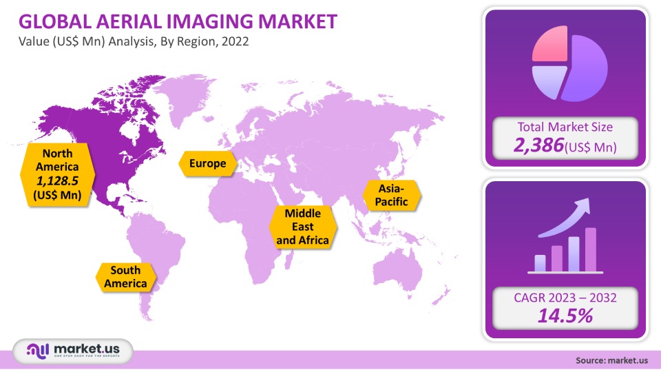
The market for aerial imaging was valued at USD 2,386 million in 2021. It is expected to grow 14.5% between 2023 and 2032. This technology is efficient for many purposes, including route design, planning, volume calculation, map renovations, etc. Aerial Imaging can be used for many purposes, including construction & design, geospatial technology, and disaster management.
Global Aerial Imaging Market Scope:
Application Analysis
Aerial imaging is used by many industries, including energy, defense, agriculture, civil engineering, and other applications. Over the forecast period, the government will be the largest end-user segment. The government uses this technology for many purposes, including urban planning, homeland security, energy management, monitoring environmental studies, and other purposes. The forecast period also predicts significant agriculture, forestry, and commercial applications growth.
A few agriculture applications involve the scheduling and evaluating fertilizers and pesticides, soil sampling, and the creation of manageable zones. Aerial imaging can be used commercially for advertising, promotion, construction progress evaluation, and other purposes. Market growth is expected to be boosted by the increasing use of aerial imagery in construction and natural resources management. Civil engineering is used for only a few purposes. Drilling and logistics are two examples of energy applications.
Platform Analysis
The global market can be divided into fixed-wing, helicopter, UAV/drones, and others. UAV/drones are expected to grow fastest and will capture approximately 45.7% global aerial imaging market share by 2021.
Кеу Маrkеt Ѕеgmеntѕ
By Application
- Government
- Military & Defense
- Energy
- Agriculture & Forestry
- Other Applications
By Platform
- fixed-wing
- helicopter
- UAV/drones
- Other Platforms
Market Dynamics:
Market growth will be driven by technological advances in aerial platforms and camera systems. Market demand will also be boosted by increasing awareness about the technology’s benefits. Over the forecast period, aerial imaging market growth will be driven by increasing demand for location-based services.
Aerial imaging market growth could be slowed by operational limitations and security concerns over the next six-year period. Market growth may be facilitated by the Personal Aerial Mapping System and Unmanned Aerial Vehicle (UAV). In the future, new camera technologies like UltraCam Osprey and Hawk by Microsoft and new trends like aerial archeology will provide opportunities for aerial imaging market growth.
Regional Analysis
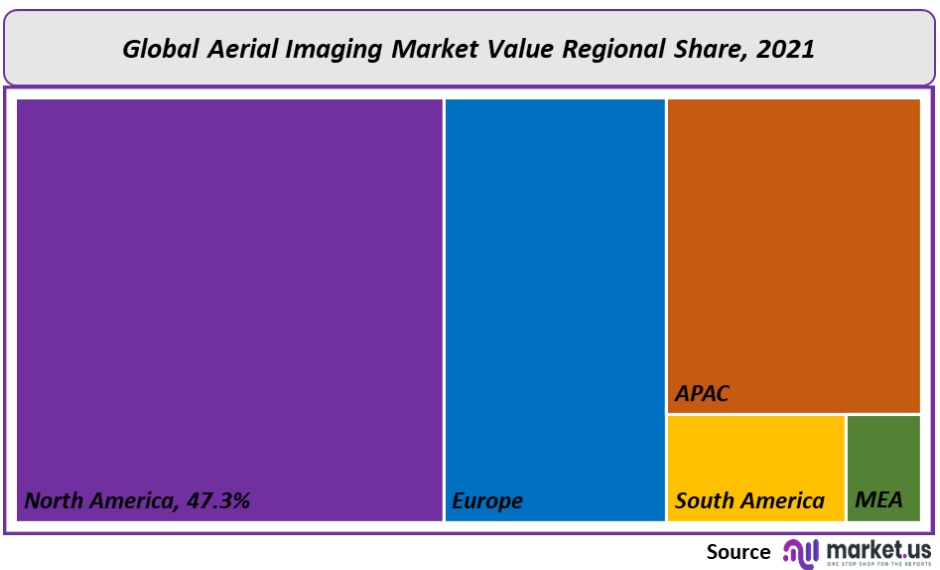
North America dominated the market by 47.3%. Due to the rapid development of UAVs and PAMS. The European aerial imaging market is expected to grow at an impressive rate during the forecast period. Due to the high defense and military investment in countries like India, China, and others, Asia-Pacific is expected to expand significantly.
Key Regions and Countries covered іn thе rероrt:
- North America
- US
- Canada
- Mexico
- Europe
- Germany
- UK
- France
- Italy
- Russia
- Spain
- Rest of Europe
- APAC
- China
- Japan
- South Korea
- India
- Rest of Asia-Pacific
- South America
- Brazil
- Argentina
- Rest of South America
- MEA
- GCC
- South Africa
- Israel
- Rest of MEA
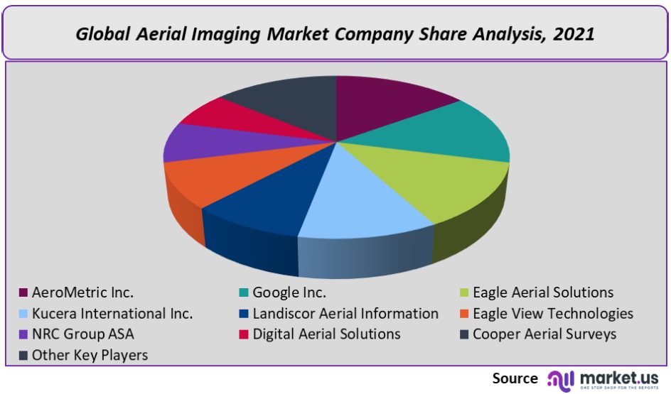
Kucera International Inc. provides aerial photography, Orth photography, and plotting. They also offer stereo compilation, volumetric surveys, and stereo compiling. Eagle View Technologies is available to serve the construction, realty, solar, GIS and energy & utility industries, as well as safety and federal applications.
Маrkеt Кеу Рlауеrѕ:
- AeroMetric Inc.
- Google Inc.
- Eagle Aerial Solutions
- Kucera International Inc.
- Landiscor Aerial Information
- Eagle View Technologies
- NRС Group АЅА
- Digital Aerial Solutions
- Cooper Aerial Surveys
- Other Key Players
For the Aerial Imaging Market research study, the following years have been considered to estimate the market size:
| Attribute | Report Details |
|---|---|
Historical Years |
2016-2020 |
Base Year |
2021 |
Estimated Year |
2022 |
Short Term Projection Year |
2028 |
Projected Year |
2023 |
Long Term Projection Year |
2032 |
Report Coverage |
Competitive Landscape, Revenue analysis, Company Share Analysis, Manufacturers Analysis, Volume by Manufacturers, Key Segments, Key company analysis, Market Trends, Distribution Channel, Market Dynamics, COVID-19 Impact Analysis, strategy for existing players to grab maximum market share, and more. |
Regional Scope |
North America, Europe, Asia-Pacific, South America, Middle East & Africa |
Country Scope |
United States, Canada and Mexico, Germany, France, UK, Russia and Italy, China, Japan, Korea, India and Southeast Asia, Brazil, Argentina, Colombia etc.Saudi Arabia, UAE, Egypt, Nigeria and South Africa |
Frequently Asked Questions (FAQ)
The Aerial imaging market size is US$ 2,386 million in 2021.
The Aerial imaging market is expected to grow at a CAGR of 14.5% (2023-2032).
Market.US has segmented the Aerial imaging market by geographic (North America, Europe, APAC, South America, and Middle East and Africa). By Application, the market has been segmented into Government, Military & Defense, Energy, Agriculture & Forestry, and Other Applications. By Platform, the market has been further divided into fixed-wing, helicopter, UAV/drones, and Other Platforms.
AeroMetric Inc., Google Inc., Eagle Aerial Solutions, Kucera International Inc., Landiscor Aerial Information, Eagle View Technologies, NRС Group АЅА, Digital Aerial Solutions, Cooper Aerial Surveys, and Other Key Players engaged in the Aerial Imaging Market.
North America is expected to account for the highest revenue share of 47.3%. Therefore, the Aerial imaging industry in North America is expected to garner significant business opportunities over the forecast period.
The US, Canada, India, China, UK, Japan, & Germany are key areas of operation for the Aerial Imaging Market.