Quick Navigation
- Report Overview
- Key Takeaway
- Role of Generative AI
- Investment and Business Benefits
- Regional Analysis
- Component Analysis
- Deployment Mode Analysis
- Technology Analysis
- Application Analysis
- End User Analysis
- Key Market Segments
- Emerging Trends
- Growth Factors
- Market Dynamics
- Key Players Analysis
- Recent Developments
- Report Scope
Report Overview
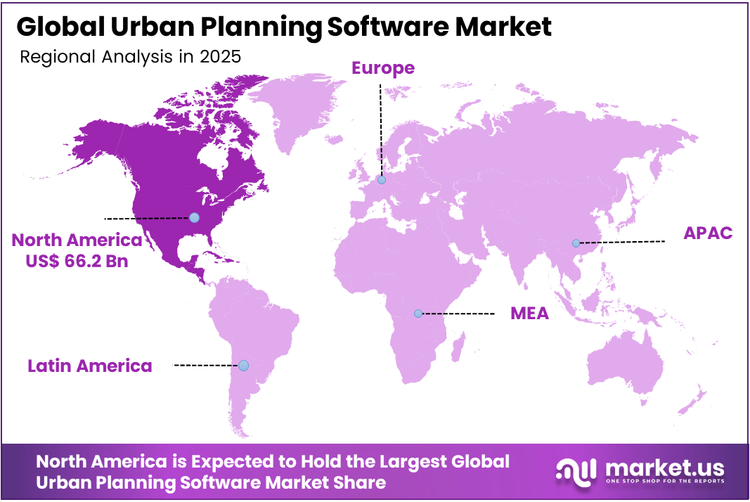
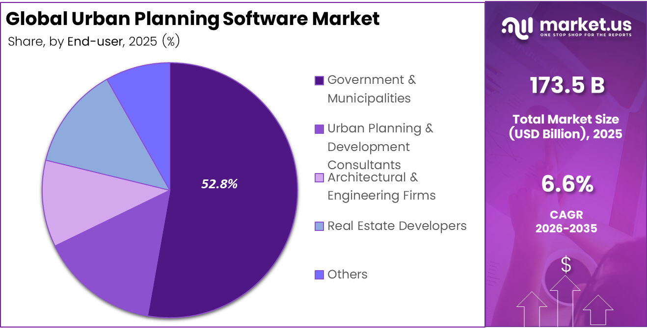
The Global Urban Planning Software Market size is expected to be worth around USD 328.7 billion by 2035, from USD 173.5 billion in 2025, growing at a CAGR of 6.6% during the forecast period from 2026 to 2035. North America held a dominant market position, capturing more than a 38.2% share, holding USD 66.2 billion in revenue.
Urban Planning Software refers to digital tools used by planners, architects, governments, and developers to design, manage, and review urban spaces. It supports land use planning, zoning, transport mapping, infrastructure coordination, and environmental analysis, helping cities make better decisions for housing, mobility, public services, and long-term development.

Top driving factors include rapid urbanisation, where more than 55% of the world already lives in cities. This is increasing pressure on water, energy, and housing systems. Climate risks such as floods, which affect hundreds of millions of residents each year, are also pushing governments to use planning tools that improve transparency and reduce costly design errors.
The market for Urban Planning Software is driven by rapid urban growth, rising smart city investments, and the need for better coordination across land use, housing, transport, and utilities. Governments and developers are using these tools to improve planning accuracy, reduce approval delays, manage climate risks, and support transparent decisions through digital maps, data analysis, and scenario-based planning.
Demand is rising as local governments move from paper-based planning to digital workflows. These platforms help coordinate transport, housing, and utilities across regions of more than 10 million people. Universities, consultants, and private developers are also adopting these tools, which support higher license use, stronger service demand, and long-term software contracts.
For instance, in September 2024, Hexagon AB continued to build out its smart-city offering by combining geospatial tools and 3D reality capture into planning workflows, helping local governments create high-resolution digital twins, test redevelopment scenarios, and monitor urban growth using continuously updated spatial data and analytics.
Key Takeaway
- In 2025, the Software segment held a dominant market position, capturing a 62.1% share of the Global Urban Planning Software Market.
- In 2025, the Cloud-based segment held a dominant market position, capturing a 59.7% share of the Global Urban Planning Software Market.
- In 2025, the Geographic Information Systems (GIS) segment held a dominant market position, capturing a 45.9% share of the Global Urban Planning Software Market.
- In 2025, the Land Use Planning & Zoning segment held a dominant market position, capturing a 37.5% share of the Global Urban Planning Software Market.
- In 2025, the Government & Municipalities segment held a dominant market position, capturing a 52.8% share of the Global Urban Planning Software Market.
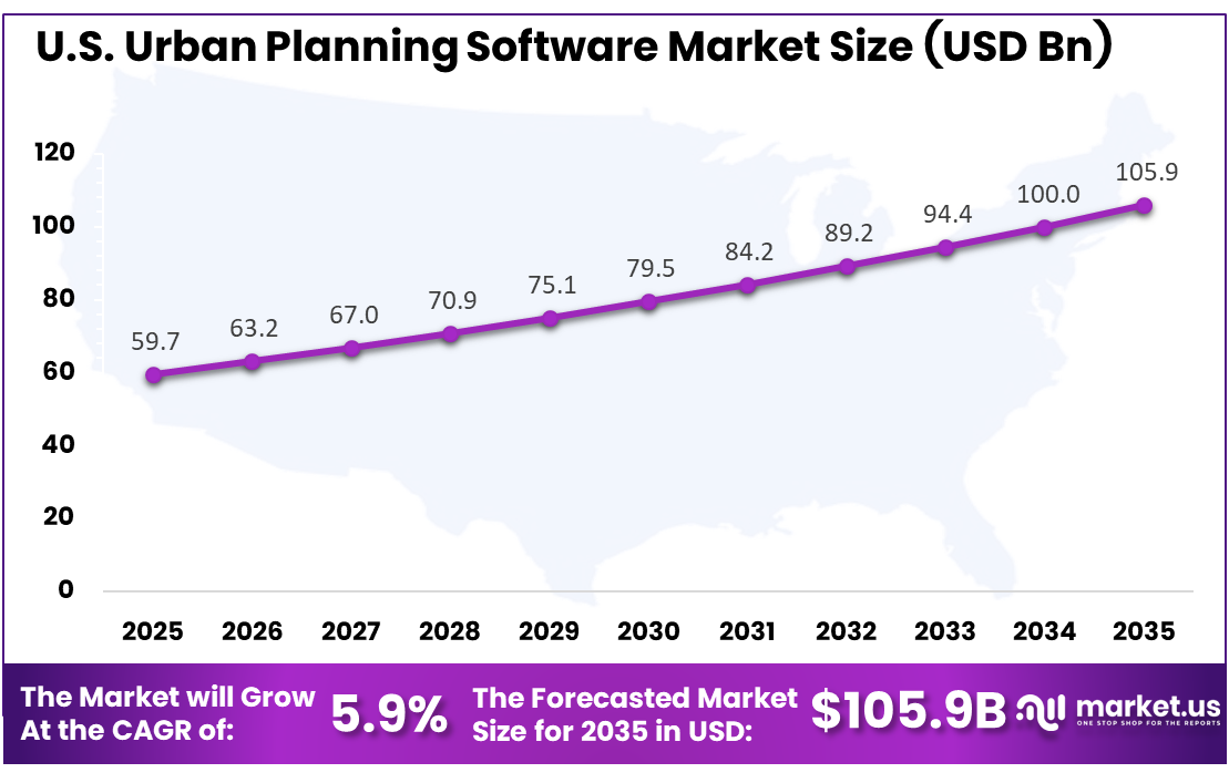
- The U.S. Urban Planning Software Market was valued at USD 59.7 Billion in 2025, with a robust CAGR of 5.9%.
- In 2025, North America held a dominant market position in the Global Urban Planning Software Market, capturing more than a 38.2% share.
Role of Generative AI
Generative AI is becoming a practical part of urban planning software, mainly in concept design, layout testing, and early scenario planning. More than 40% of new AI planning studies now focus on generative models, compared with less than 10% a few years ago, showing fast adoption in research and practice.
Planners use generative tools to create street layouts, density options, and land use mixes based on daylight, flood risk, and zoning rules. These tools can reduce early design work from weeks to hours. AI-supported workflows can also shorten some masterplan review cycles by up to 60% through automated rule testing.
Investment and Business Benefits
Investment opportunities are growing in AI-powered analytics, cloud-based collaboration suites, 3D digital twins, and integration layers. These tools can connect planning software with building permits, tax records, and mobility apps used by over 100 thousand daily commuters. Strong scope is also seen in climate resilience, flood risk mapping, and energy-efficient district design.
Business benefits include recurring subscriptions, consulting income, and strong customer lock-in for software vendors. Once cities upload years of land use and asset data, platforms often remain active over 5 to 10-year cycles. For users, these systems reduce rework, improve department coordination, and lower conflicts between transport, housing, and environmental planning.
Regional Analysis
In 2025, North America held a dominant market position in the Global Urban Planning Software Market, capturing more than a 38.2% share, holding USD 66.2 billion in revenue. This dominance is due to the strong digital maturity of planning agencies, wider use of GIS platforms, and steady investment in smart city infrastructure. Cities across the region are adopting software to manage zoning, transport, housing, utilities, and climate resilience in a more coordinated way. Growth is also supported by cloud-based planning tools, advanced mapping systems, and the need for transparent, data-driven public decision-making.
For instance, in September 2024, UrbanFootprint continued to expand its deployment with U.S. utilities and public agencies, using high-resolution demographic, climate, and infrastructure datasets to help cities model housing capacity, transit demand, and climate risk, reinforcing North America’s dominance in scenario-based urban planning analytics built on rich, localized data.
U.S. Urban Planning Software Market Size
The market for Urban Planning Software within the U.S. is growing tremendously and is currently valued at USD 59.7 billion; the market has a projected CAGR of 5.9%. The market is growing due to rising urban redevelopment, stronger demand for smart infrastructure planning, and the need for faster approval workflows. Public agencies are using digital tools to manage zoning, housing, transport, utilities, and climate risks with better accuracy. Growth is also supported by cloud platforms, GIS integration, and data-based planning methods that help cities make clearer and more transparent decisions.
For instance, in August 2024, Urban SDK grew its footprint with North American city and state departments of transportation, offering cloud dashboards that fuse traffic, safety, and mobility data so planners can prioritize Vision Zero projects, redesign dangerous corridors, and support grant applications, underscoring U.S. leadership in real-time mobility-focused urban planning tools.
Key Regions and Countries
North America
- US
- Canada
Europe
- Germany
- France
- The UK
- Spain
- Italy
- Russia
- Netherlands
- Rest of Europe
Asia Pacific
- China
- Japan
- South Korea
- India
- Australia
- Singapore
- Thailand
- Vietnam
- Rest of APAC
Latin America
- Brazil
- Mexico
- Rest of Latin America
Middle East & Africa
- South Africa
- Saudi Arabia
- UAE
- Rest of MEA
Component Analysis
In 2025, the Software segment held a dominant market position, capturing a 62.1% share of the Global Urban Planning Software Market. This dominance is due to the growing use of digital tools for zoning, land use modelling, map-based review, and planning approvals. Software helps planning teams bring policy rules, spatial data, and design options into one workflow, which improves accuracy and reduces the time spent on manual checks.
Urban agencies also prefer software because it supports scenario planning, public consultation, and long-term infrastructure coordination. It allows planners to compare development options, review environmental impact, and share visual outputs with decision makers. This makes software a core part of modern urban planning operations.
For instance, in September 2025, Autodesk expanded its Forma platform to link early site planning with detailed building design, giving planners a smoother way to test options and refine schemes in one environment. This kind of integration helps software tools stay central to urban projects, since teams can move from concept to more detailed design without losing context.
Deployment Mode Analysis
In 2025, the Cloud-Based segment held a dominant market position, capturing a 59.7% share of the Global Urban Planning Software Market. This dominance is due to the need for flexible access, faster collaboration, and easier data sharing across planning departments. Cloud-based platforms allow city teams, consultants, and project partners to work on the same planning data without depending on local systems or complex internal storage.
Cloud deployment also supports frequent updates, remote access and smoother integration with GIS, mobility, and environmental datasets. It is useful for municipalities that manage several planning projects at once. This helps reduce delays, improve review quality and support better coordination between public and private stakeholders.
For instance, in November 2025, Esri rolled out an ArcGIS Online update that brought new collaboration and content management features, helping organisations manage spatial data in a fully hosted environment. The release underlines how cloud services are becoming the default place for map sharing, team editing, and publishing planning content to internal and public users.
Technology Analysis
In 2025, the Geographic Information Systems (GIS) segment held a dominant market position, capturing a 45.9% share of the Global Urban Planning Software Market. This dominance is due to the central role of location-based data in urban planning. GIS helps planners understand land parcels, transport routes, public assets, flood zones and service coverage. It gives planning teams a clear spatial view, which supports better decisions in zoning and infrastructure planning.
GIS is also widely used because it connects maps with policy, demographic and environmental information. This helps planners identify development pressure, service gaps and land use conflicts more clearly. As cities become more complex, GIS remains a trusted technology for evidence-based planning and municipal management.
For instance, in October 2025, Trimble announced GIS-centric mapping and asset tracking enhancements in its Unity software suite, aimed at better monitoring of infrastructure networks. For city planners, these functions support more accurate mapping of utilities and public assets, linking GIS analysis directly to maintenance and permitting workflows.
Application Analysis
In 2025, the Land Use Planning & Zoning segment held a dominant market position, capturing a 37.5% share of the Global Urban Planning Software Market. This dominance is due to the rising need to manage land use, housing density, transport access and development controls more effectively. Urban planning software helps planners test zoning options, review building capacity and identify conflicts before approvals are issued, making the planning process more structured.
Land use and zoning tools also support better transparency in public decision-making. They allow agencies to compare different planning scenarios and explain the likely impact of each option. This is important for cities dealing with population growth, limited land availability and rising pressure on public infrastructure.
For instance, in January 2026, Autodesk detailed new Forma site design features that improve terrain editing, environmental analysis, and early-phase carbon checks for development sites. These tools help planners evaluate land use options, building forms, and environmental impacts before zoning decisions are made, which supports more informed land use planning.
End User Analysis
In 2025, the Government & Municipalities segment held a dominant market position, capturing a 52.8% share of the Global Urban Planning Software Market. This dominance is due to the strong role of public agencies in zoning, land approvals, infrastructure planning and city governance. Government and municipal bodies use planning software to manage spatial data, review proposals, coordinate public services and support long-term urban development decisions.
Municipalities also need these tools to improve transparency and reduce delays in planning approvals. Digital systems help departments share information, track project status and respond to community needs with better evidence. This makes urban planning software an important part of modern public administration.
For instance, in October 2025, Bentley’s Infrastructure Cloud Connect was presented as a secure entry point for agencies to manage infrastructure files, correspondence, and geospatial data in one environment. Government and municipal users can use this connected data space to coordinate across departments and maintain a clearer record of planning and infrastructure decisions.
Key Market Segments
By Component
- Software
- Services
By Deployment Mode
- Cloud-based
- On-premises
By Technology
- 3D Modeling & Visualization
- Geographic Information Systems (GIS)
- Building Information Modeling (BIM)
- Others
By Application
- Land Use Planning & Zoning
- Transportation & Infrastructure Planning
- Urban Design & Visualization
- Environmental Impact Assessment
- Others
By End User
- Government & Municipalities
- Urban Planning & Development Consultants
- Architectural & Engineering Firms
- Real Estate Developers
- Others
Emerging Trends
A major trend is the move toward integrated urban platforms that combine GIS, 3D modelling, mobility analytics, and environmental simulation. Digital twins are gaining strong attention as they keep city models updated with sensor data, construction changes, and policy inputs, helping planning teams review large master plans more efficiently.
Another trend is the automation of routine rule checks and data preparation. AI-enabled tools can create building massing models from cadastral and zoning layers, while flagging non-compliant designs in real time. This allows planners to focus more on design quality, public needs, and stakeholder negotiation.
Growth Factors
One key growth factor is rapid urbanisation and rising pressure on land, infrastructure, and public services. With more than 68% of people expected to live in cities by 2050, planning departments need software that can test density, transport, and green space options faster than traditional planning methods.
Another factor is the shift toward data-driven decision-making in planning and infrastructure departments. Public agencies now need clear, traceable, and scenario-based evidence for major decisions. This is increasing demand for software that can visualise impacts, monitor KPIs, and support collaboration across departments.
Market Dynamics
Drivers - Smart City and Sustainability Push
Smart city programs are increasing the use of urban planning software as cities look for better ways to manage land, transport, housing, and public assets. These tools help planning teams test development choices and align projects with sustainability goals before major investments are made.
Sustainability targets are also pushing cities to use software for climate risk review, green space planning, and energy-efficient urban design. Planners can compare different scenarios, identify weak areas, and make decisions with stronger evidence. This makes digital planning tools more important for modern city development.
For instance, in March 2025, Autodesk participated in South by Southwest, where its leadership discussed technology-driven approaches to building sustainable cities. The company showcased how digital solutions integrate urban design principles with environmental goals, helping municipalities plan infrastructure that supports long-term sustainability objectives while managing urban growth efficiently.
Restraint - High Cost and Integration Complexity
High implementation cost remains a key restraint for many public agencies and smaller municipalities. Urban planning software often requires licensing, data migration, training, and system customization. These costs can slow adoption, especially where planning budgets are limited or digital infrastructure is still developing.
Integration is another concern because cities often use older systems for permits, land records, tax data, and infrastructure management. Connecting these systems with modern planning platforms can be complex and time-consuming. Poor integration may reduce efficiency and limit the full value of the software.
For instance, in June 2025, LightBox acquired UrbanFootprint to expand location intelligence capabilities with climate and infrastructure data. The integration aims to weave UrbanFootprint’s demographic, land use, and environmental hazard models across the broader platform, demonstrating the complexity of combining specialized planning analytics with enterprise real estate intelligence systems.
Opportunities - AI and Data Rich Planning Platforms
AI and data-rich planning platforms create strong opportunities by helping planners test scenarios, detect risks, and compare development options faster. These tools can support land use analysis, zoning checks, traffic impact review, and climate resilience planning, making planning work more accurate and less dependent on manual processes.
As cities collect more data from sensors, maps, permits, and mobility systems, software vendors can build platforms that turn this information into practical planning insights. Strong opportunities exist for tools that combine GIS, AI, cloud access, and visual dashboards for better coordination across planning departments.
For instance, in June 2025, Urban SDK launched artificial intelligence-enabled features for its platform serving over 250 city and county clients across the United States. The update introduced automated workflows that generate customized reports, location-specific alerts for traffic safety, and centralized data management tools allowing municipalities to combine their own datasets with provider information for deeper roadway analysis.
Challenges - Data Quality, Privacy, and Governance
Data quality is a major challenge because planning software depends on accurate, updated, and complete information. If land records, zoning layers, or infrastructure data are outdated, planning outputs can become unreliable. This may lead to poor decisions, project delays, and disputes between public agencies, developers, and communities.
Privacy and governance concerns are also rising as cities use more location, mobility, and property-related data. Clear rules are needed for data access, sharing, and public use. Without strong governance, agencies may face public resistance and lower trust in digital planning decisions.
For instance, in March 2025, Esri added blueprint upload and media layer storage capabilities within the ArcGIS Urban site plans. The feature enables teams to georeference and share development documents within collaborative environments, raising questions about access governance, version control, and intellectual property protection as multiple stakeholders contribute information throughout planning cycles.
Key Players Analysis
One of the leading players in February 2025, Autodesk, Inc., expanded its urban design toolkit by deepening integration between InfraWorks, Civil 3D, and cloud-based collaboration in Autodesk Construction Cloud, helping city planners coordinate 3D infrastructure, zoning, and stakeholder feedback in a single environment, and reinforcing Autodesk’s role as a core platform for large, data-heavy urban planning projects.
Top Key Players in the Market
- Autodesk, Inc.
- Esri, Inc.
- Bentley Systems, Incorporated
- Hexagon AB
- Trimble, Inc.
- Avenue
- Dassault Systèmes SE
- CityCAD Technologies
- UrbanFootprint
- PlanTime
- Urban SDK
- Arcadis NV
- AECOM
- Stantec Inc.
- Others
Recent Developments
- In October 2024, Bentley Systems, Incorporated advanced its OpenCities and OpenRoads portfolio by aligning 3D city modeling, mobility simulation, and asset data in a common environment, allowing municipalities to evaluate transport corridors, utilities, and land-use trade-offs together and supporting more resilient, long-life urban infrastructure programs worldwide.
- In July 2024, Trimble, Inc. strengthened SketchUp’s role in planning by promoting it as a core urban design and visualization tool, tying it into Trimble’s broader construction and geospatial stack so planners can move from early-stage massing to detailed infrastructure models while keeping geometry, context data, and stakeholder inputs aligned.
Report Scope
| Report Features | Description |
|---|---|
| Market Value (2025) | USD 173.5 Billion |
| Forecast Revenue (2035) | USD 328.7 Billion |
| CAGR (2026-2035) | 6.6% |
| Base Year for Estimation | 2025 |
| Historic Period | 2020-2024 |
| Forecast Period | 2026-2035 |
| Report Coverage | Revenue Forecast, Market Dynamics, Competitive Landscape, Recent Developments |
| Segments Covered | By Component (Software, Services), By Deployment Mode (Cloud-based, On-premises), By Technology (3D Modeling & Visualization, Geographic Information Systems (GIS), Building Information Modeling (BIM), Others), By Application (Land Use Planning & Zoning, Transportation & Infrastructure Planning, Urban Design & Visualization, Environmental Impact Assessment, Others), By End User (Government & Municipalities, Urban Planning & Development Consultants, Architectural & Engineering Firms, Real Estate Developers, Others) |
| Regional Analysis | North America (US and Canada), Europe (Germany, France, The UK, Spain, Italy, and Rest of Europe), Asia Pacific (China, Japan, South Korea, India, Australia, and Rest of APAC), Latin America (Brazil, Mexico, and Rest of Latin America), Middle East & Africa (GCC, South Africa, and Rest of MEA) |
| Competitive Landscape | Autodesk, Inc., Esri, Inc., Bentley Systems, Incorporated, Hexagon AB, Trimble, Inc., Avenue, Dassault Systèmes SE, CityCAD Technologies, UrbanFootprint, PlanTime, Urban SDK, Arcadis NV, AECOM, Stantec Inc., Others |
| Customization Scope | Customization at the segment and region/country levels will be provided. Moreover, customization can be tailored to the requirements. |
| Purchase Options | We have three licenses to opt for: Single User License, Multi-User License (Up to 5 Users), Corporate Use License (Unlimited Users and Printable PDF) |